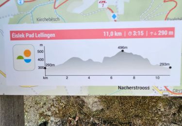
![](/images/other/stat-length.png)
![Trail Walking Parc Hosingen - 2023-06-19_15h10m22_eislek-pad-hoscheid-1 (1) - Photo](https://media.geolcdn.com/t/1900/400/ext.pjpeg?maxdim=2&url=https%3A%2F%2Fstatic1.geolcdn.com%2Fsiteimages%2Fupload%2Ffiles%2F1553511878bg_sport_marche.png)
2023-06-19_15h10m22_eislek-pad-hoscheid-1 (1)
mumu.larandonneuse
User GUIDE
![Length](/images/other/stat-length.png)
![Max alt](https://static1.geolcdn.com/siteimages/upload/files/1508320355ic_sort_altitude_max_24dp.png)
![Uphill gradient](https://static1.geolcdn.com/siteimages/upload/files/1508320355ic_sort_den_pos_24dp.png)
![Km-Effort](/images/other/stat-length.png)
![Min alt](https://static1.geolcdn.com/siteimages/upload/files/1508320355ic_sort_altitude_min_24dp.png)
![Downhill gradient](https://static1.geolcdn.com/siteimages/upload/files/1508320355ic_sort_den_neg_24dp.png)
![Boucle](https://static1.geolcdn.com/siteimages/upload/files/16400158638029165_repeat_loop_refresh_sync_direction_icon.png)
![Walking](https://static1.geolcdn.com/sitytour/trail-icons/101.png)
4h05
Difficulty : Medium
![Scan this QR Code to open this trail in the SityTrail application](https://capi.geolives.com/qq0zvz2zws4bq2lad0pu/sitytour/trails/3704939/qr.png?size=200)
FREE GPS app for hiking
About
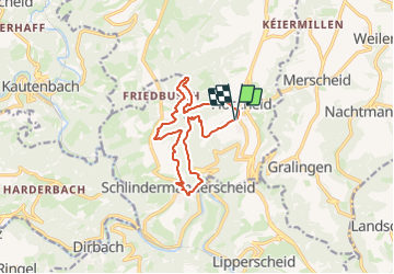
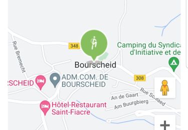
Trail Walking of 11.6 km to be discovered at Unknown, Canton Clervaux, Parc Hosingen. This trail is proposed by mumu.larandonneuse.
Description
• Sur la crête étroite •
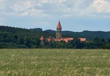
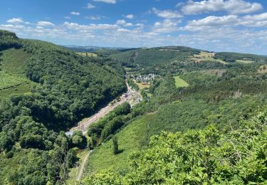
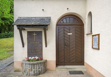
Ce sentier mène à travers la vallée de Schlindertal, où un renard "fabuleux" aurait fait des bêtises. Un petit détour vous conduira à son monument. La chapelle Saint-Michel se dresse toute seule avec son aura mystique et se réjouit de votre visite. Le point culminant de la visite est le Molberlee, une crête d'ardoise accidentée exposée avec une vue magnifique sur la vallée.
ℹ️ www.visit- eislek.lu
Positioning
Comments
Trails nearby
![Trail Walking Bourscheid - Autopedestres : Bourscheid - Photo](https://media.geolcdn.com/t/375/260/ext.jpg?maxdim=2&url=https%3A%2F%2Fstatic1.geolcdn.com%2Fsiteimages%2Fupload%2Ffiles%2F1553511878bg_sport_marche.png)
![Walking Walking](https://static1.geolcdn.com/sitytour/trail-icons/101.png)
Walking
![](/images/other/stat-length.png)
![](https://static1.geolcdn.com/siteimages/upload/files/16400158638029165_repeat_loop_refresh_sync_direction_icon.png)
![Trail Walking Kiischpelt - eislek trail de Kautenbach à Troisvierges - Photo](https://media.geolcdn.com/t/375/260/fa22f2d8-d5f7-4d5a-bd3c-5a3522af9299.jpg&format=jpg&maxdim=2)
![Walking Walking](https://static1.geolcdn.com/sitytour/trail-icons/101.png)
Walking
![](/images/other/stat-length.png)
![](https://static1.geolcdn.com/siteimages/upload/files/16400158638029165_repeat_loop_refresh_sync_direction_icon.png)
![Trail Walking Kiischpelt - 2023-06-19_15h16m15_eislek-pad-lellingen-1 - Photo](https://media.geolcdn.com/t/375/260/b5d867db-7edb-46bc-9488-bc2835d5be2c.jpg&format=jpg&maxdim=2)
![Walking Walking](https://static1.geolcdn.com/sitytour/trail-icons/101.png)
Walking
![](/images/other/stat-length.png)
![](https://static1.geolcdn.com/siteimages/upload/files/16400158638029165_repeat_loop_refresh_sync_direction_icon.png)
![Trail Walking Kiischpelt - 2022-09-22_13h29m24_t62885235_eislek pad kautenbach (1) - Photo](https://media.geolcdn.com/t/375/260/0c0135b5-3869-4e5e-9de6-2c826fdc4a40.jpg&format=jpg&maxdim=2)
![Walking Walking](https://static1.geolcdn.com/sitytour/trail-icons/101.png)
Walking
![](/images/other/stat-length.png)
![](https://static1.geolcdn.com/siteimages/upload/files/16400158638029165_repeat_loop_refresh_sync_direction_icon.png)
![Trail Walking Bourscheid - 2022-09-22_13h10m58_t62880921_eislek pad bourscheid - Photo](https://media.geolcdn.com/t/375/260/22286de4-94ea-4b92-acbb-a4fc138a2ba8.jpg&format=jpg&maxdim=2)
![Walking Walking](https://static1.geolcdn.com/sitytour/trail-icons/101.png)
Walking
![](/images/other/stat-length.png)
![](https://static1.geolcdn.com/siteimages/upload/files/16400158638029165_repeat_loop_refresh_sync_direction_icon.png)
![Trail Walking Kiischpelt - Escapardenne Eisleck Trail: Kautenbach - Clervaux - Photo](https://media.geolcdn.com/t/375/260/86b391f6-6800-4c48-b33b-03a021b1a218.jpeg&format=jpg&maxdim=2)
![Walking Walking](https://static1.geolcdn.com/sitytour/trail-icons/101.png)
Walking
![](/images/other/stat-length.png)
![](https://static1.geolcdn.com/siteimages/upload/files/16400158638029165_repeat_loop_refresh_sync_direction_icon.png)
![Trail Walking Parc Hosingen - Escapardenne Lee Trail: Hoscheid - Kautenbach - Photo](https://media.geolcdn.com/t/375/260/8bf23a72-7eca-4436-91e5-2141dda4e2a9.jpeg&format=jpg&maxdim=2)
![Walking Walking](https://static1.geolcdn.com/sitytour/trail-icons/101.png)
Walking
![](/images/other/stat-length.png)
![](https://static1.geolcdn.com/siteimages/upload/files/16400158638029165_repeat_loop_refresh_sync_direction_icon.png)
![Trail Walking Bourscheid - Escapardenne Lee Trail: Moulin de Bourscheid - Hoscheid - Photo](https://media.geolcdn.com/t/375/260/d49b1826-4b3a-4793-bf5a-6d813972bfaf.jpeg&format=jpg&maxdim=2)
![Walking Walking](https://static1.geolcdn.com/sitytour/trail-icons/101.png)
Walking
![](/images/other/stat-length.png)
![](https://static1.geolcdn.com/siteimages/upload/files/16400158638029165_repeat_loop_refresh_sync_direction_icon.png)
![Trail On foot Bourscheid - Autopedestre Schlindermanderscheid - Photo](https://media.geolcdn.com/t/375/260/b96de446-0e31-4144-a1e8-49f30dc2459e.jpeg&format=jpg&maxdim=2)
![On foot On foot](https://static1.geolcdn.com/sitytour/trail-icons/100.png)
On foot
![](/images/other/stat-length.png)
![](https://static1.geolcdn.com/siteimages/upload/files/16400158638029165_repeat_loop_refresh_sync_direction_icon.png)